Building Earth’ Landscapes
Tectonics
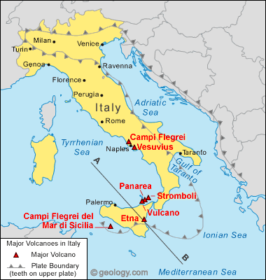
Italy is placed between three
tectonic plates; they are the Eurasian plate, the African, and the Anatolian
plate. The Eurasian plate takes up most of Italy
and the African plate only takes up an eastern region of Italy (look at
the map for reference). The interactions of these three plates can help explain
Italy’s
mountain formations as well as the volcanic activity.
![[Map of tectonic plates and fault lines around Italy]](http://www.npr.org/news/graphics/2009/apr/italy-earthquake/italy_earthquake_570.jpg)
http://www.npr.org/news/graphics/2009/apr/italy-earthquake/
Volcanoes
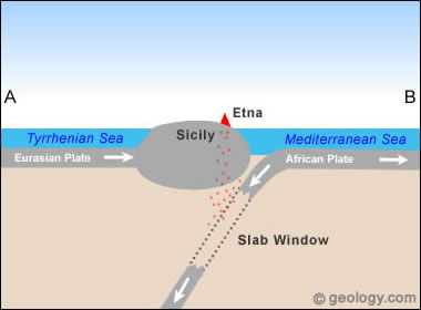
Mt. Etna is
the largest volcano in Italy
and it is an extrusive volcanic landform. Italy has several active volcanoes.
Etna is located on the island
of Sicily (see map for
reference). The volcano is formed because of a convergence or subduction of the
two plates; the Eurasian and the African plate. Mt. Etna
is a cinder cone volcano; it was an example that is in the class notes. The volcanic
material that the volcano has is called tephra, which are rocks that are blown
out of the volcano. There are several volcanoes that are around each other and
they are formed due to subduction zones of the two plates and are close to
mountains. As stated in the notes, “volcanoes rest on top of mountains” and
much of Italy
is covered in mountains.
Mountains
The mountains that are formed in Italy
are formed because of compression between the Eurasian and African plates. They
were compressed together and mountains formed throughout Italy. Because
of the activity of these two plates, Italy gets earthquakes. The most recent one was in May, and it occurred
in northern Italy
along the fault lines of tectonic plates. Tectonic activity affects people in Italy
because inn the southern part of the Eurasian and African plate volcanoes form
while in the northern part earthquakes occur. People are affected by volcanic
activity and earthquakes that cause issues with health, safety, and shelter.

No comments:
Post a Comment